Downloadable Files
You can download Denmark Landscape Photography Google for free at the end of this page.
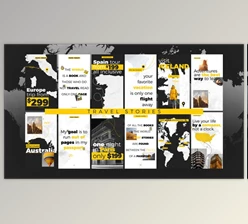
Explore Hidden Denmark Through a Unique Photography Map
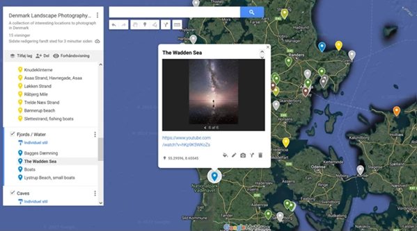
If you are one of the individuals who are fascinated by discovering new places, landscapes, abandoned spots, and other spots that are perfect for photography, then this project will pique your interest. The Denmark Landscape Photography Google is a project that includes 89 locations in Denmark that have been visited and photographed in YouTube videos.
Some of these spots include personal photos and videos that potential photographers and explorers can use to explore these spots even further. There are 89 spots in total, with more to be added in the future. However, places that might be too sensitive to include will not be part of this project.
What Is Denmark Landscape Photography Google?
Denmark Landscape Photography Google is a project that has been created for individuals who are interested in photography, travel videos, road trips, and the various landscapes that might be hidden in the nation of Denmark.
Instead of including 100 spots simply for the purpose of showcasing them, the spots that have been chosen for inclusion in this project have all been explored by the creator in real life, in videos, and in their travels. The following components are included in this project:
- Landscape photography locations
- Cinematic spot locations
- Real travel experiences
- Inspiration photos for each spot
- YouTube video links for each spot
- Google Maps integration support
Real Experiences Instead of Generic Tourist Lists
One of the strongest aspects of this project is authenticity. Every marked place comes from personal exploration and field experience rather than copied travel recommendations. This creates several advantages:
- Locations feel more unique and cinematic
- Users can preview real visual results through photos
- YouTube links help understand the atmosphere of each place
- The map becomes useful for planning photography trips and creative projects
For photographers and creators, this dramatically improves trip planning because you can visually estimate lighting conditions, terrain style, and composition opportunities before visiting.
Features
Carefully Selected Photography Locations
There are dozens of spots that have been chosen specifically for their potential for landscape photography and exploration. These spots include, but are not limited to, spots that include coastal cliffs, forests, rural areas, hidden spots, abandoned locations, and cinematic roads. Only selected spots for photography have been chosen for inclusion in this project.
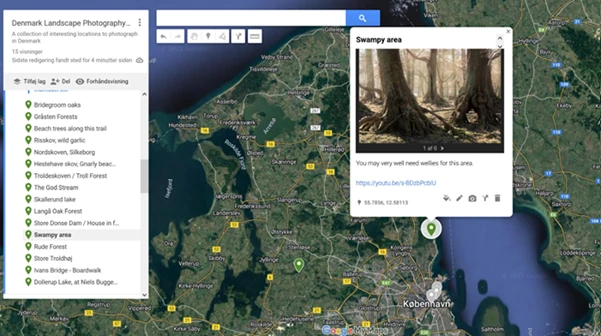
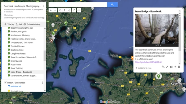
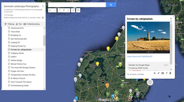
Integrated YouTube Video References
Many locations contain direct links to YouTube videos where the creator visits and documents the place in real life. This feature helps users:
- Experience the location before visiting
- Understand weather and lighting conditions
- Discover photography ideas
- Learn travel routes and accessibility
For visual creators, this turns the map into a hybrid travel and filmmaking guide.
Built-In Inspiration Photos
Several map markers also include personal photography images that showcase the mood and visual potential of each destination. This is especially useful for:
- Landscape photographers
- Drone pilots
- Travel filmmakers
- Social media creators
- Adventure vloggers
Seeing real examples can help users better prepare compositions, lenses, timing, and shooting styles.
Google Maps Integration Support
The PDF explains how to properly use the project with Google Maps and Google My Maps. Since these are different platforms, many users may not know how to integrate them correctly. The included instructions simplify the process and make the experience much smoother. Important details include:
- A Google account is required for full integration
- The map can still be viewed directly in a browser without an account
- Users can save and organize locations inside their own Google Maps ecosystem
This makes long-term travel planning far more convenient.
Practical Creative Uses
Build Better Photography Road Trips
One of the best uses of Denmark Landscape Photography Google is planning photography-focused road trips. Instead of searching endlessly for locations, users instantly gain access to curated spots already proven to work visually. This saves:
- Research time
- Fuel costs
- Location scouting effort
- Missed photography opportunities
Discover Cinematic Filming Spots
Travel filmmakers and YouTubers can use the map to discover atmospheric environments suitable for cinematic storytelling. Because many locations were originally filmed for YouTube, they naturally work well for:
- Drone sequences
- Slow cinematic shots
- Nature storytelling
- Documentary-style filming
- Travel mont
Improve Social Media Content Quality
Creators looking to improve Instagram, YouTube Shorts, or TikTok visuals can benefit greatly from location inspiration included in the map. Interesting environments naturally improve:
- Composition quality
- Audience engagement
- Visual storytelling
- Brand aesthetics
Sometimes the location itself becomes the strongest creative tool.
Professional Tips for Better Results
Visit During Golden Hour
Many landscape locations become dramatically more cinematic during sunrise or sunset. Soft light improves:
- Color depth
- Texture visibility
- Atmospheric mood
- Shadow balance
Planning visits around golden hour can completely transform the final result
Study The Linked Videos Before Visiting
Watching the connected YouTube videos beforehand helps users understand:
- Parking accessibility
- Walking distances
- Camera angles
- Seasonal conditions
- Safety considerations
This preparation can make photography sessions more efficient and enjoyable.
Respect Nature and Private Areas
Many of the fragile and private spots have been intentionally excluded from this project. It is essential that these principles are followed by all individuals who explore these spots. By respecting these spots and their environments, future photographers can continue to explore and showcase them in their content.
Final Thoughts
Overall, Denmark Landscape Photography Google is a project that has been built from real experiences, exploration of photography spots, and the ability to tell stories about these spots. By incorporating inspiration spots, YouTube videos, and Google My Maps support, this project has the potential to aid all photographers, filmmakers, explorers, and travel enthusiasts who travel to Denmark seeking more authentic experiences.
Whether planning a road trip, seeking filming spots, or even just looking for photography inspiration, this project will allow individuals to explore the country of Denmark in a unique way.

Files Password : gfxplugin.com OR 123456